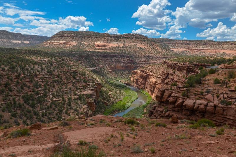
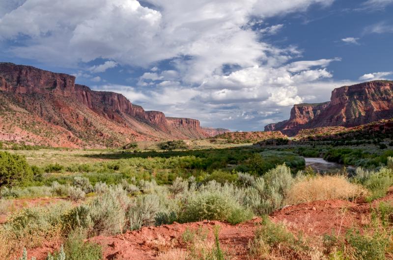
Proposed Dolores Canyons National Monument
Public Meeting to discuss the Proposed Dolores Canyons National Monument
Senator Michael Bennet will host a public meeting to discuss the Proposed Dolores Canyons National Monument this coming Sunday, June 9, at 3 p.m. at the West End Schools Pre-K to 12 Building, 225 W. 4th Ave. in Nucla.
If you’d like to attend, please RSVP here. If you cannot attend but would like to share your opinion, your comments are welcome here.
Learn more about the Proposed Dolores Canyons National Monument here.
Mesa County Commissioners adopt resolution opposing the proposed Dolores Canyons National Monument
On May 14, 2024, the Mesa County Board of Commissioners adopted a resolution in opposition to the creation of the Dolores Canyons National Monument. This comes in response to the Protect the Dolores Coalition's initiative to designate an approximately 390,000-acre area encompassing parts of Mesa, Montrose, and San Miguel counties as a national monument.
Dolores Canyon National Monument Opposition Resolution_Adopted 5.14.2024
To continue to the full news release, click here.
Survey reveals 60% of community members oppose the Proposed Dolores Canyons National Monument
On April 30, 2024, the Board of Mesa County Commissioners and the public were briefed on a comprehensive and scientific opinion survey conducted by Magellan Strategies on April 24, 2024. Residents of Mesa, Montrose, and San Miguel counties weighed in on the future of the Dolores Canyons area, a region under consideration for national monument status.
The survey, which includes responses from 1,272 residents, provides insight into the community's views on land management, conservation efforts, and the proposed national monument designation. While there is significant support for conserving public lands, with 72% in favor, a majority of 60% oppose the national monument designation, primarily due to concerns over increased restrictions, desire for local control, and potential negative impacts on the local economy and environment.
Do the Dolores Canyons need more protection?
The Protect the Dolores Coalition has proposed creation of a new National Monument. The proposed Dolores Canyons National Monument, lies in western Mesa, Montrose and San Miguel counties and is currently shown to contain approximately 390,000 acres. Proponents of the effort state:
The Protect the Dolores Coalition is proposing that a Dolores Canyons National Monument be designated on public lands surrounding the Dolores River in the western portions of Mesa and Montrose counties. The designation would only apply to public lands managed by the Bureau of Land Management and Forest Service. Private lands will not be impacted. Following designation, these land management agencies would develop a new management plan through a public process that solicits input and expertise from local residents.
Opposing the monument proposal is the Halt the Dolores group, which highlights potential impacts on outdoor recreation, agriculture, and mining that could result from the designation of a national monument.
While the boundaries of the proposed national Monument are not set in stone and discussions are ongoing in many communities, Mesa County feels it is important to gather as much information and garner the opinions of as many area residents as possible as this decision will undoubtedly change the way many work and recreate in Western Colorado.
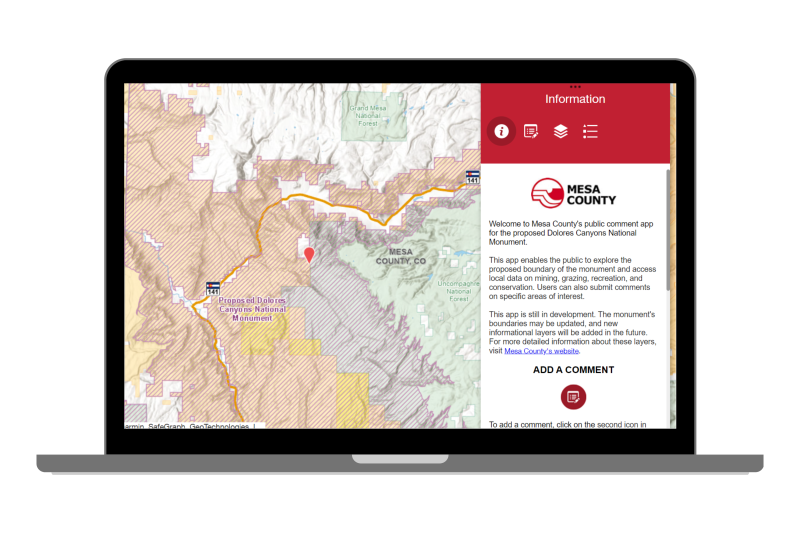
Proposed Dolores Canyons National Monument mapping tool
*Please note: the identified boundaries of the Proposed Dolores Canyons National Monument are subject to change pending ongoing discussions with stakeholders.
The Proposed Dolores Canyons National Monument mapping tool features current management layers, including conservation lands, wildlife habitats, trails and roads, mining and critical minerals areas, recreation zones, grazing allotments, and areas of emergency management concern.
Using this feedback tool to collect input from the public and area stakeholders is crucial for effectively determining the best path forward for this section of the Dolores Canyons. This information will also aid in acknowledging and respecting various interests, and ensures both conservation and community goals are considered as we continue to discuss options for this area.
As a transportation plan update is likely if a national monument is designated, feedback is critical for making informed decisions about which roads or trails may be closed, ensuring important access is maintained for recreational, traditional, or emergency purposes. It helps identify cultural or historical trails that should stay open and suggests alternatives to reduce environmental harm. Without proper feedback, there could be unintended restrictions on access to important areas, negatively affecting the community, recreational activities, and emergency responses.
Input from the community is also critical for ensuring water managers are able to maintain and improve water infrastructure, which is essential for agriculture and drinking water. Similarly, feedback on grazing leases is important to understand the importance of each allotment and their effects on area agriculture, land health, and wildlife.
Given the mining history of the area, future management of mineral extraction and balancing these important resources with conservation and recreation, requires stakeholder input. This can highlight where mining has minimal environmental impact, address concerns about land degradation, and protect valuable ecological or cultural sites, while ensuring future opportunities for responsible resource development.
Management of our public lands
America's public lands are managed in a number of ways. Some areas are so important that they warrant special designations to ensure their protection and preservation for future generations. These designations can include national parks, wilderness areas, national monuments, and other classifications that prioritize conservation and sustainable use. Each designation comes with its own set of regulations and management practices to balance the needs of conservation, recreation, and resource use.
The Department of Interior (DOI) explains some of the many ways they manage these special areas in America's Public Lands Explained.
According to the National Park Service:
A “national monument” is a type of park designation. The Antiquities Act at Section 2 defines national monuments as: “confined to the smallest area compatible with proper care and management of the objects to be protected[.]” According to the National Parks Index, “A national monument is intended to preserve at least one nationally significant resource. It is usually smaller than a national park and lacks its diversity of attractions.”
Not all national monuments are established the same way. Some are created by presidents using the authority of the Antiquities Act. Congress also creates national monuments through the legislative process.
The Presidential Proclamation provides details such as "reference to the legal authority/authorities, date of signing/date of establishment, president’s name, a description of scientific values (the rationale for setting aside the national monument), description of boundaries, designation of federal agency manager, and amount of land set aside."1 It will also dictate that the governing agency will begin developing a new Resource Management Plan (RMP) that will guide future management of the monument. This process is governed by NEPA or the National Environmental Policy Act.
Mesa County is home to the Colorado National Monument established in 1911. National monuments designated today are managed for a variety of purposes, primarily to protect and preserve at least one significant resource. These resources may be natural, cultural, or scientific resources. While the specific management objectives can vary depending on the monument, these lands are managed to balance conservation and the protection of important natural and cultural resources with public access and enjoyment. Management focus generally includes:
- Conservation: Protecting and preserving unique or rare ecological features, habitats, and species.
- Cultural Preservation: Preserving archaeological sites, historic structures, and culturally significant landscapes.
- Recreation: Providing opportunities for outdoor recreation such as hiking, camping, and wildlife viewing while ensuring the protection of natural and cultural resources.
- Education: Offering opportunities for public education and interpretation of the monument's natural and cultural resources.
- Scientific Research: Supporting scientific research and monitoring to better understand and manage the monument's resources.
- Sustainable Use: Managing the monument's resources in a sustainable manner to ensure they can be enjoyed by present and future generations.
National Monuments may also be managed by the Bureau of Land Management or the US Forest Service. These newer monuments tend to be more conservation focused, rather than preservation focused like those managed by the National Park Service. Regarding the 14.9 million acres of National Monuments and National Conservation Area Programs, the BLM states "These areas are managed to conserve, protect, restore, and enhance America’s national and cultural heritage, while providing compatible multiple uses including grazing, oil, gas and mining."2
Footnotes:
1How to Research Antiquities Act National Monuments from the National Park Service. Retrieved April 2, 2024.
2 National Conservation Lands: Monuments and National Conservation Areas from the U.S. Department of the Interior, Bureau of Land Management. Retrieved April 29, 2024.
The US Department of the Interior explains that National Conservation Areas (NCAs) are "public lands managed by the Bureau of Land Management that are set aside for the benefit and enjoyment of present and future generations. Like national parks, national conservation areas are designated by Congress and feature scientific, cultural, historical and recreational features."
Mesa County is home to two National Conservation Areas:
Montrose County is home to one National Conservation Area:
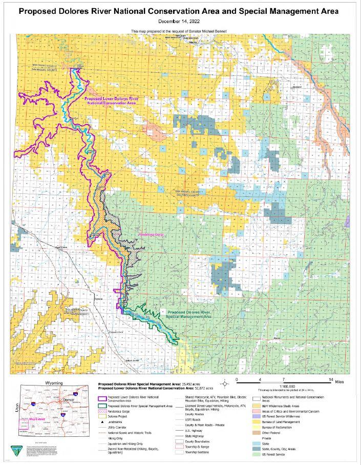
Dolores Canyon National Conservation Area Map
Legislation has been introduced by Colorado Senators Bennet and Hickenlooper (S.636) and Representative Bobert (H.R. 1534) "to protect the southern portion of the Dolores River watershed—in Montezuma, Dolores, and San Miguel counties—as a national conservation area (NCA)."1
This legislation, the Dolores River National Conservation Area and Special Management Area Act, is the culmination of more than a decade of dialogue and cooperation among a diverse stakeholder group. This group includes landowners, various user groups, local and Tribal governments, water managers, and conservation organizations.
Footnotes:
Public Lands are managed according to a land management plan, similar to a county's comprehensive plan. These plans serve as a blueprint for the public land and are developed in accordance to a National Environmental Policy Act ("NEPA") process. The area proposed for the Dolores Canyons National Monument traverse portions of the following Resource Management Plans (“RMPs”) and Forest Plans:
- Bureau of Land Management Grand Junction Field Office RMP
- Bureau of Land Management Uncompahgre Field Office RMP
- Bureau of Land Management Tres Rios Field Office RMP
- US Forest Service Grand Mesa, Uncompahgre and Gunnison National Forest Plan
- US Forest Service Manti- La Sal National Forest Plan
These plans identify management areas for recreation, timber extraction, oil and gas and mineral extraction and grazing, as well as areas that require special management such as timing limitations, protections for plant and species habitat, critical watersheds, and more. Some of the protective management designations are listed below. There are also plans that manage specific resources such as Travel Management, species such as the Gunnison Sage-grouse or for uses such as the 2012 Western Solar Plan.
Wilderness Areas are the most protective tool available to federal land managers and is defined as as a place "where the earth and its community of life are untrammeled by man, where man himself is a visitor who does not remain."1 Established by Congress in 1964, the Wilderness Act... "The uniquely American idea of wilderness protects wild and natural landscapes ranging from alpine to desert, forest to grassland, and other environments of the United States. Wilderness protects the habitat of numerous wildlife species and provides a source of clean water. It has long been used for science and education, providing sites for field trips, study areas for student research, and serving as a source of instructional examples."2 Wilderness areas are recommended for designation, Congress then enacts legislation, and upon agreement by the House and Senate, the president will sign the legislation into law.3
Wilderness Areas in Mesa County include:
Wilderness Areas in Montrose County include:
Wilderness Study Areas (WSAs) "are places that have wilderness characteristics; that is a minimum size, naturalness, and outstanding opportunities for recreation which make them eligible for designation as wilderness... The establishment of a WSA served to identify areas for Congress to consider for addition to the National Wilderness Preservation System. Today, the BLM manages WSA that contain about 11.1 million acres of public land. Until Congress makes a decision to add or end consideration of a WSA, the BLM manages the area to ensure its suitability for designation as wilderness is not impaired."2 WSAs are typically designated by Congress. Additionally, there have been a few cases in which the Bureau of Land Management (BLM) has identified WSAs during planning processes under Section 202 of the Federal Land Policy and Management Act of 1976.
Lands with Wilderness Characteristics (LWCs), according to the BLM, "For an area to qualify as lands with wilderness characteristics, it must possess sufficient size, naturalness, and outstanding opportunities for either solitude or primitive and unconfined recreation. It may also possess supplemental values. Section 201 of Federal Land Policy and Management Act (FLPMA) requires the BLM to maintain an inventory of all public lands and their resources and other values, which includes wilderness characteristics. It states that the preparation and maintenance of the inventory shall not, of itself, change or prevent change of the management or use of public lands. Lands with wilderness characteristics are inventoried separately from designated Wilderness or wilderness study areas (WSAs)."4
Areas of Critical Environmental Concern (ACECs) are “lands where special management attention is required to protect and prevent irreparable damage to important historical, cultural, or scenic values, fish and wildlife resources or other natural systems or processes, or to protect life and safety from natural hazards.”5 ACECs are nominated and evaluated during an RMP process and must meet both relevance and importance criteria (43 CFR 1610.7-2).
Colorado Roadless Areas are "important because they are, among other things, sources of drinking water, important fish and wildlife habitat, semi-primitive or primitive recreation areas, including motorized and non-motorized recreation opportunities, and naturally appearing landscapes." the Colorado Roadless Rule was created in response to "Uncertainty about the future of the 2001 Roadless Rule, along with state-specific concerns." The Department of Agriculture, US Forest Service and State of Colorado agreed that "timber cutting, sale, or removal and road construction/reconstruction have the greatest likelihood of altering and fragmenting landscapes, resulting in immediate, long-term loss of roadless area characteristics. Therefore, there is a need to generally prohibit these activities in roadless areas."6 Colorado has 4,433,000 acres of Inventoried Roadless Areas."7
Resource Management Plans (RMPs) encompass a wide array of land management decisions tailored to specific resource management goals. These decisions, shaped by the plan's objectives and the resources under management, aid in balancing conservation and utilization. In addition to designations like WSAs, LWCs, and ACECs, an RMP may also include: identification of special and extensive recreation areas that experience higher usage, delineation of areas suitable and unsuitable for target shooting or dispersed camping, provisions for future rights-of-way permits for solar, wind, and transmission structures, designation of areas requiring timing limitations for specific uses (e.g., oil and gas development, timber extraction) to protect certain species, travel management restrictions in big game winter ranges and during sage grouse lekking and brood rearing periods, and regulations addressing noise disturbances.
Footnotes:
1 U.S. House of Representatives. Title 16, Section 1131.
2 National Conservation Lands: Wilderness from the Bureau of Land Management.
3 Wilderness Designation from Wilderness.net.
4 Lands with Wilderness Characteristics from the Bureau of Land Management.
5 Title 43, Chapter 35 from the U.S. Government Publishing Office.
6 Federal Register from the U.S. Department of Agriculture, Forest Service.
7 State Maps from the U.S. Department of Agriculture, Forest Service.
While Mesa County is diligently collecting and reviewing all information provided through the mapping tool, we also strongly encourage you to reach out to your State Senators and Representatives, County Commissioners, and City or Town Councilmembers. Your direct engagement with these officials is vital in shaping the outcome of this important decision.
Ways to contact elected officials are provided below.
Make your voice heard
US Senator Michael Bennet
Visit Senator Bennet's Website
Mailing Address:
Cesar E. Chavez Memorial Building
1244 Speer Boulevard
Denver, CO 80204
Toll Free phone: 866-455-9866
Phone: 303-455-7600
Fax: 202-224-1866
US Senator John Hickenlooper
Visit Senator Hickenlooper's Website
Mailing Address:
Byron Rogers Federal Building
1961 Stout Street
Suite 12-300
Denver, CO 80294
Phone: 303-244-1628
US House District 3 Lauren Boebert
Visit Representative Boebert's Website
Washington DC Office:
1713 Longworth House Office Building
Washington, DC 20515
Phone: (202) 225-4761
Grand Junction District Office:
743 Horizon Court
Suite 112
Grand Junction, CO 81506
Phone: 970-208-0460
Interested in contacting other Colorado legislators? Visit the Colorado General Assembly for the Legislator Directory.
District 2: Bobbie Daniel, Chair
District 1: Cody Davis
District 3: Janet Rowland
District 1: Keith Caddy, Vice-Chair
District 3: Roger Rash, Chair
District 2: Sue Hansen, Commissioner
District 1: Anne Brown
Email Anne Brown
District 2: Lance Waring
Email Lance Waring
District 3: Kris Holstrom
Email Kris Holstrom