The Grand Valley Fluvial Hazard Zone Map
Fluvial Hazard Zones (FHZs)
FHZs show areas that a stream may:
- Currently occupy
- Have occupied recently
- Influence through erosion and sediment transport
The Grand Valley FHZ has been mapped for most of the Colorado and Gunnison Rivers in Mesa County as part of the Colorado Water Conservation Board’s Fluvial Hazard Zone Program.
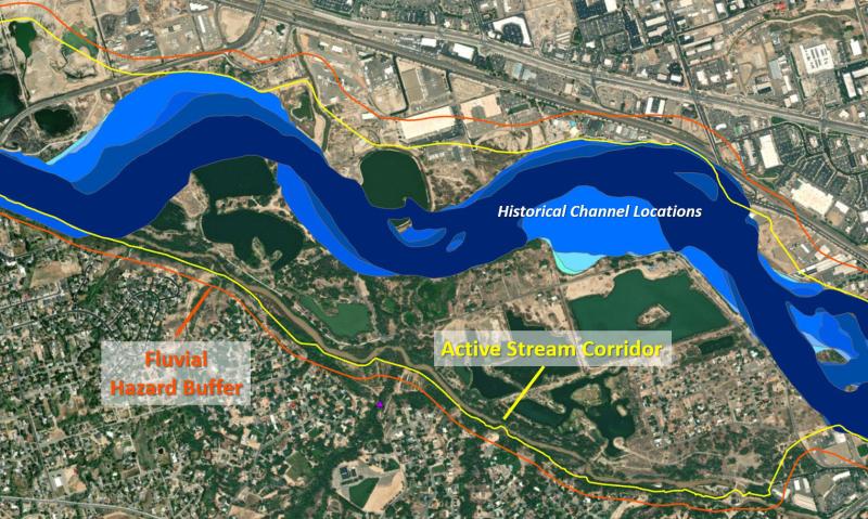
Components of the Grand Valley FHZ
The Active Stream Corridor, shown below in yellow, defines the corridor within which the Colorado and Gunnison Rivers would migrate over time without the influence of development or infrastructure in the floodplain. Dynamic river processes like bank erosion and deposition occur in this corridor.
The Fluvial Hazard Buffer, shown in red below, is the margin that extends into hillslopes and other areas that bracket the Active Stream Corridor. This zone, often thought of as being “high and dry” can still be vulnerable to erosion and hillslope failure resulting from a dynamic river. Its width is influenced by the local geology and proximity to the active channel.
Other components of the FHZ are described in the FHZ Fact Sheet.
Is the FHZ regulated?
There are no regulations, zoning ordinances, or permit requirements associated with the Grand Valley FHZ in Mesa County at this time. The FHZ map, like other geologic hazard maps, is provided for public information only. Still, the Grand Valley FHZ can be used to better understand the risks that exist in a certain area prior to development or starting a project.
My property is in the FHZ. What does this mean?
If your property is within the FHZ, this indicates that it may, at some point, experience the processes associated with FHZs such as erosion, sediment deposition, and resultant flooding. However, it is important to note that the FHZ does not provide a probability or time frame during which these processes and events may occur.
The FHZ should be interpreted at a 1:25,000 scale and is better suited for parcel-level projects rather than site-scale development. A more detailed geohazard or geotechnical analysis is required for site-scale development and design. Be sure to consult the Floodplain Management Program to discuss flood risk information for your development prior to beginning construction.